Difficulty level
High
Steeper ascents, difficult hiking terrain
Length and elongation
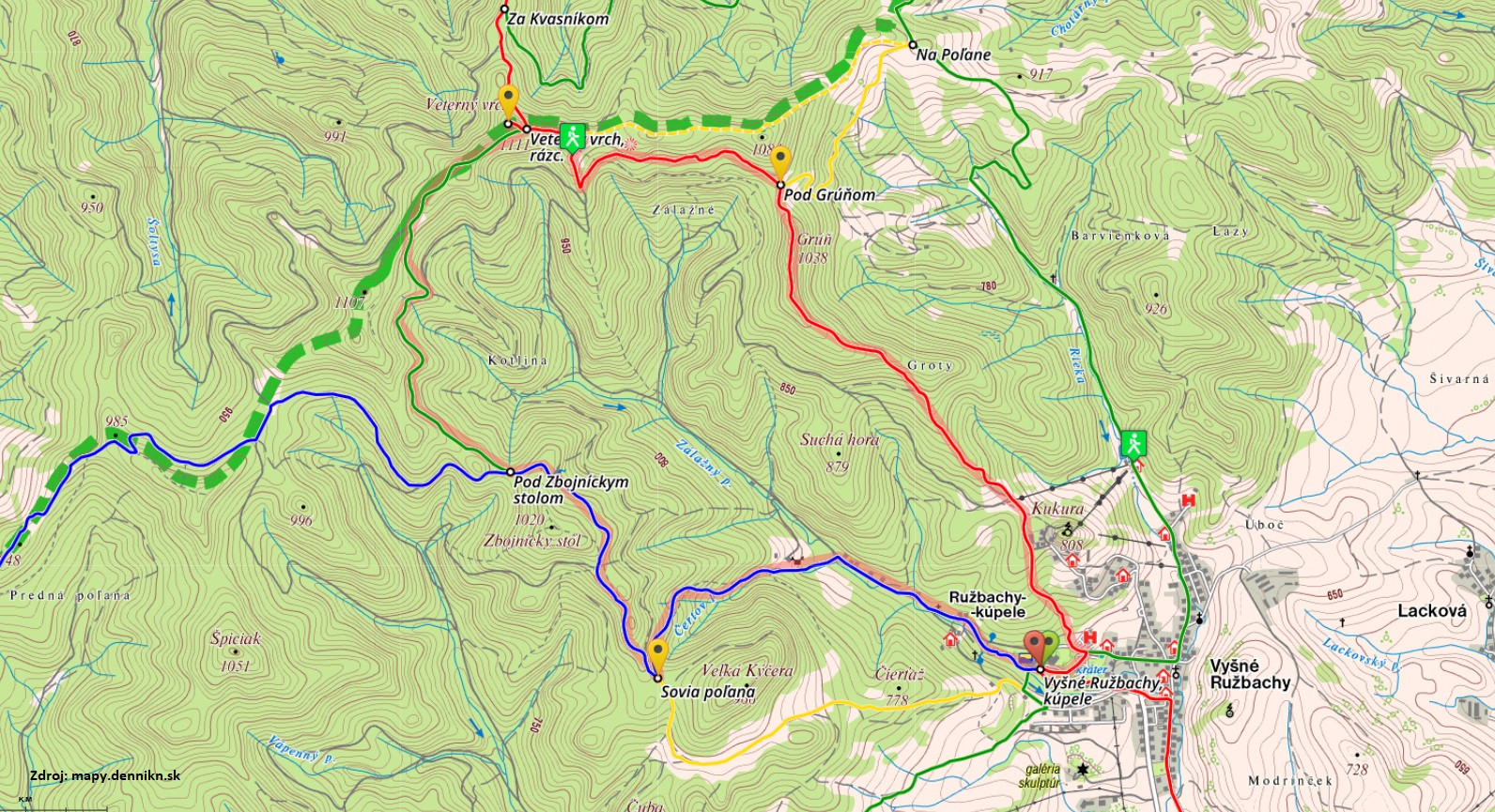
15.7 km; 691 vertical meters
Required outfit
Hiking shoes, suitable clothes, walking poles (recommended), a headlamp, food, a drink
Duration
5.5 hours, at a hiking pace
This beautiful hiking trip is a rather difficult challenge for those who are physically fit. Therefore, we recommend considering our advice before you hit the road. You should start early in the morning and preferably not alone. In spring, the higher areas are usually still covered with snow; in summer, bear in mind that the weather can change fast; in autumn, a day might surprisingly get very short; and winter is a combination of all the previous risks. However, if one feels certain, the trip will bring a reward in form of wonderful feelings and satisfaction. This Oxygen Route – Air starts at the same point as all the other hiking routes in the spa, i.e. near the signpost by the entrance to the summer-time mountain outdoor swimming pool. The trail leads on the red-marked path around the Balneotherapy building to the famous tree in the stone. Opposite the tree, there is a signpost hanging on a fence, showing directions to your route. Right after you leave the spa resort, near the travertine holes, you will have to climb up a rather steep slope. Pass a small cabin and then walk behind a relatively large wooden villa, ascending up the woods to a meadow saddle where the Vyšné Ružbachy ski-lifts end. This is the spot where you can enjoy the first wonderful views.
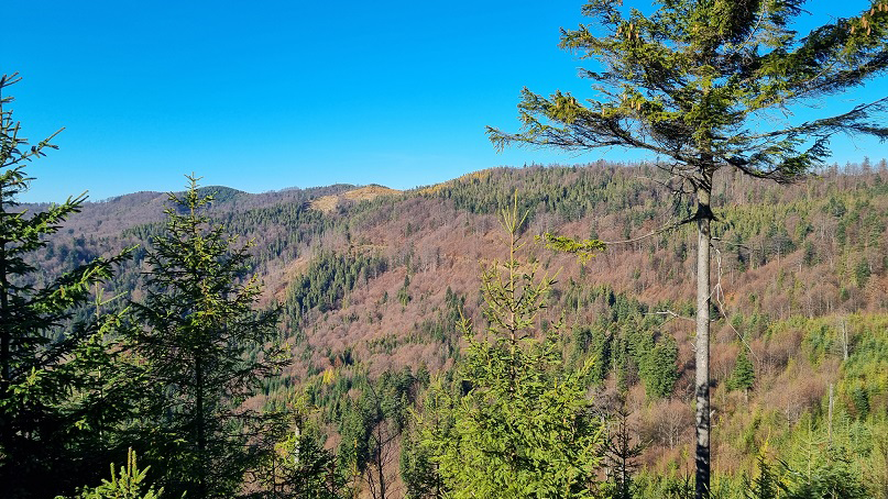
The red-marked trail will then lead you from the meadows above the ski-lifts to a slightly ascending section, almost hidden in the forest. Walking up a wide road, you will overcome a few horizontal meters. At some spots, forest windows show beautiful views of the surrounding nature. You should particularly look at the ridge on the west as this is what you will have to cross on your journey, and if you manage it all, it will lead you back to the spa. At that point, however, you still have to climb up the ridge, and the higher you are, the more beautiful are the views behind your back, towards the extensive Levoča Mountains.
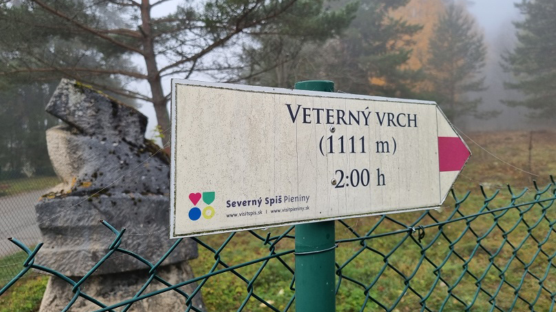
A milestone on your journey is a gazebo for hikers with a signpost showing the path to the monument of three partisans who were killed at that very place in the war in 1944. The monument is slightly off the path so if you have time, you may go and see it. The signpost also shows a path to Veterný Vrch hill, indicating a 1-hour journey. However this time only applies to those who can keep a fast hiking pace. Regardless, continue your journey up the steep ridge to its top where the terrain breaks a little and become less steep.
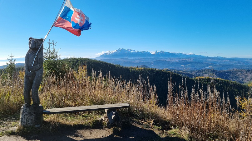
Although you will still have to ascend for some time, the terrain will not be as steep as the one near the spa. It will get flatter after a few hundreds of meters and you will continue on almost a flat ridge, with only slight elevations. This section is very pleasant. Follow the red markers until you arrive to the reward for your effort—views to both sides between the trees. Once you get to the spot on the top with a bench—Grúň hill—you may enjoy not only a view of the Tatras but also notice the U Borsuka Cottage on the opposite slope on the left. You will be passing it very soon.
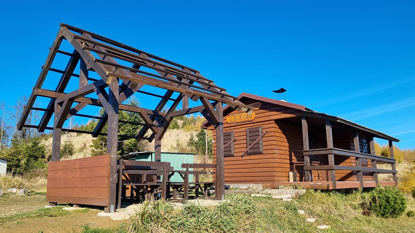
From the top of Grúň hill, walk down to a saddle under the hill. There, you may wish to reconsider your strength and power as the journey ahead is more than double the previous one, and if you do not feel fresh, or if it is too late, it is better to return back to the spa and try it some other time. However, if everything is fine, walk down from the saddle under the Grúň hill and continue on a wide road on the left, with only a slight traversing ascent up the hill. Make sure to turn right under the cottage, following the red markers up the hill. Pass the cottage and continue towards the ridge trail on the Veterný Vrch hill. At the time this article was written, the U Borsuka Cottage was closed.
Once you get to the top of Veterný Vrch hill, you may enjoy views of the valley where Veľký Lipník and Haligovce villages are situated. You will certainly spot the panorama of Three Crowns and majestic Haligovce Rocks, meadows of Šľachovky or a sharp peak of Vysoké Skalky hill. Many sections of the trail heading towards Veterný Vrch hill are in a shadow and generally colder, till you get under the very top, where a signpost will show you the way. Continue on the trail marked with a red triangle that symbolises the peak which will soon be reached. Eventually, after approximately five minutes from the intersection under Veterný Vrch hill, you will reach the highest point of this Oxygen Route.
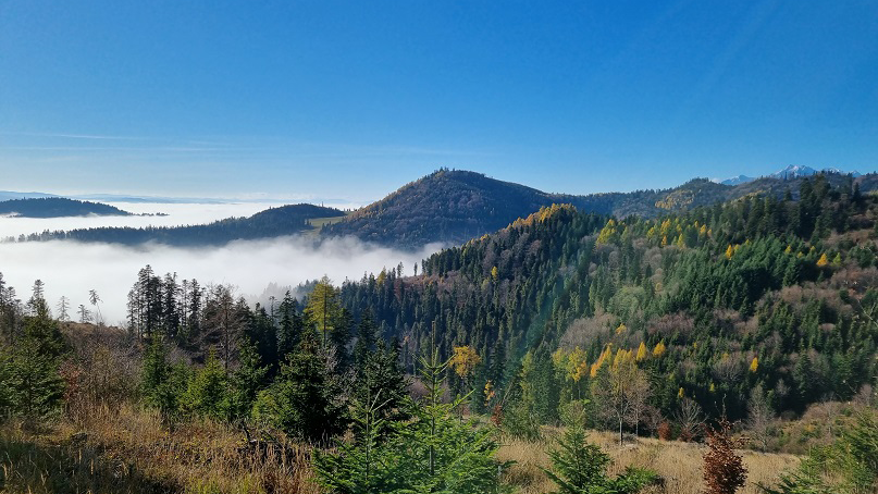
Veterný Vrch hill offers amazing views, probably the best ones in the whole Spišská Magura region. A 365° panoramic view is comparable to the views offered by famous Slovak hills, such as Choč, Kľak or Vápeč. A beautiful scenery of the eastern part of the High Tatras is supplemented with a full view of the Belianske Tatras, from Skalné vráta to the northern part with Ždiarska Vidla, Havran, Nový vrch and Muráň hills. On sunny days, you may also see part of the Polish Tatras with the Giewont Mount as well as the interesting Babia hora and Pilsko hills in the Orava Region. When looking on Kráľova Hoľa hill in the Low Tatras, you will also see the whole Levoča Mountains. Anyhow, see all that yourselves and let us know how you liked the views from the Veterný Vrch hill.
Veterný vrch (Windy Hill)
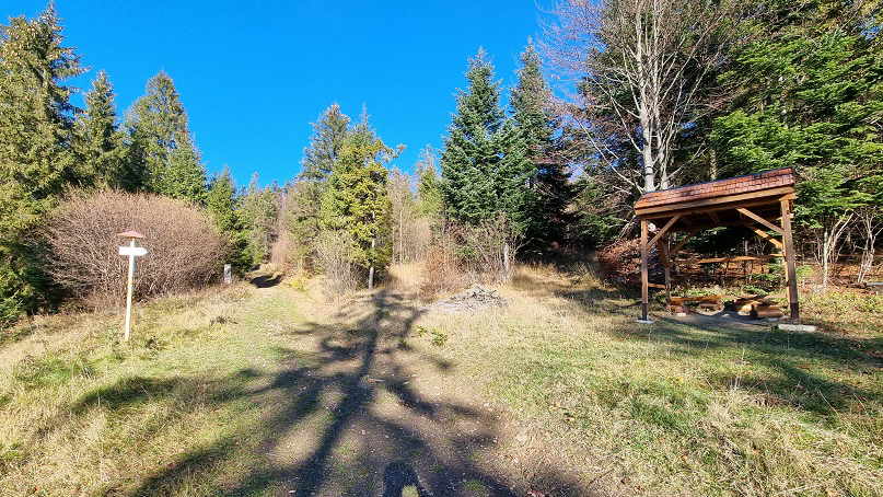
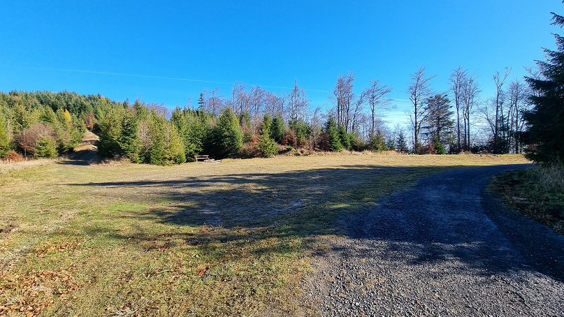
After you fully enjoy all those amazing views, and after taking some rest on pleasant spots with benches, you may start walking down the hill on the same path, and after a few meters you will get to a signpost. Turn right and follow red markers until you reach Plontana Saddle. There is one more slight ascending section ahead, but from now on, you will mostly descend. The Plontana Saddle is easily recognisable—it is a large meadow with a gazebo, benches, a fireplace, and it is intersected by an old asphalt road connecting Podolínec and Veľký Lipník villages. At this point, your journey will continue on that road towards Podolínec.
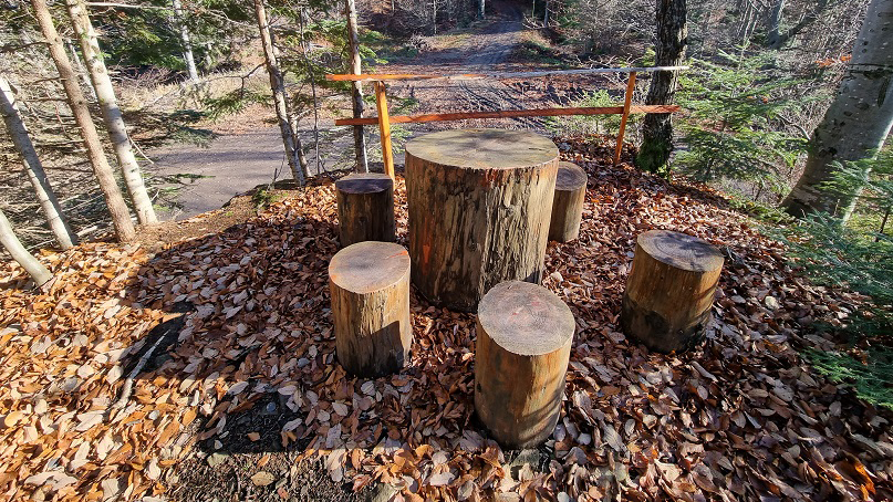
Although walking on an old asphalt road may be a bit dull, you may cheer up by enjoying the views into the forest on the left. The closest milestone is an intersection under Zbojnícky stôl (Table of Outlaws). Although Zbojnícky stôl is the name of the hill under which you will walk, one actual table of outlaws can be found directly on that intersection, as indicated by a wooden arrow. Directly above the intersection, there is a small plane with a wooden table, chairs, and an amazing view of the whole intersection. So for a while you may become an outlaw controlling the whole area. Then, your journey will continue straight up the hill along the blue trail towards Sovia poľana meadow.
The path from Zbojnícky stôl leads up the hill, but it does not take long to get to the top. After a few hundreds of meters, the terrain breaks again and the path is more-less descending.
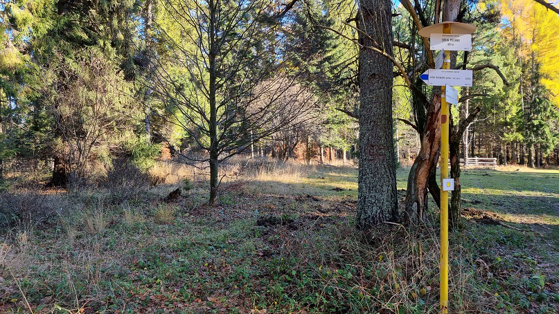
The forest terrain will offer a few more open spots where the path traverses on the right side of the ridge. Hence, you will have a couple of chances to enjoy beautiful views of the valley around Podolínec, and your sight will rest on the peaks of the High Tatras. After you reach the intersection at Sovia poľana meadow, you may choose either to continue on the blue trail across the valley to the spa, or take the yellow trail across some more meadows. This section is partially the same as the Oxygen Route – Forest. If the terrain is wet, we recommend taking the yellow trail since the blue one is rather muddy on the way down the hill. However, the original trail continues down the blue path.
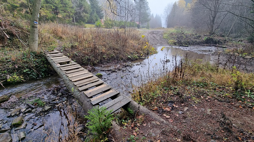
At that point, you will have to complete the last section of your journey, a forest path leading to an asphalt road in the valley of the Zálažný Stream. Even though it is often muddy, you may follow it down to a wooden bridge. The stream offers a change of getting some refreshment with clean water and cleaning your shoes from mud. Once you cross the bridge, turn right, walk down the valley, passing several cottages, until you reach a turn off the road. Follow the blue marker that will lead you to the Love and Oblivion Springs. From that point, it is just a short distance to the spa. In the spa, you will deserve having a cup of coffee, a cake or a luxury dinner in the Grand Hotel Strand****.
The red-marked trail will then lead you from the meadows above the ski-lifts to a slightly ascending section, almost hidden in the forest. Walking up a wide road, you will overcome a few horizontal meters. At some spots, forest windows show beautiful views of the surrounding nature. You should particularly look at the ridge on the west as this is what you will have to cross on your journey, and if you manage it all, it will lead you back to the spa. At that point, however, you still have to climb up the ridge, and the higher you are, the more beautiful are the views behind your back, towards the extensive Levoča Mountains.
A milestone on your journey is a gazebo for hikers with a signpost showing the path to the monument of three partisans who were killed at that very place in the war in 1944. The monument is slightly off the path so if you have time, you may go and see it. The signpost also shows a path to Veterný Vrch hill, indicating a 1-hour journey. However this time only applies to those who can keep a fast hiking pace. Regardless, continue your journey up the steep ridge to its top where the terrain breaks a little and become less steep.
Although you will still have to ascend for some time, the terrain will not be as steep as the one near the spa. It will get flatter after a few hundreds of meters and you will continue on almost a flat ridge, with only slight elevations. This section is very pleasant. Follow the red markers until you arrive to the reward for your effort—views to both sides between the trees. Once you get to the spot on the top with a bench—Grúň hill—you may enjoy not only a view of the Tatras but also notice the U Borsuka Cottage on the opposite slope on the left. You will be passing it very soon.
From the top of Grúň hill, walk down to a saddle under the hill. There, you may wish to reconsider your strength and power as the journey ahead is more than double the previous one, and if you do not feel fresh, or if it is too late, it is better to return back to the spa and try it some other time. However, if everything is fine, walk down from the saddle under the Grúň hill and continue on a wide road on the left, with only a slight traversing ascent up the hill. Make sure to turn right under the cottage, following the red markers up the hill. Pass the cottage and continue towards the ridge trail on the Veterný Vrch hill. At the time this article was written, the U Borsuka Cottage was closed.
Once you get to the top of Veterný Vrch hill, you may enjoy views of the valley where Veľký Lipník and Haligovce villages are situated. You will certainly spot the panorama of Three Crowns and majestic Haligovce Rocks, meadows of Šľachovky or a sharp peak of Vysoké Skalky hill. Many sections of the trail heading towards Veterný Vrch hill are in a shadow and generally colder, till you get under the very top, where a signpost will show you the way. Continue on the trail marked with a red triangle that symbolises the peak which will soon be reached. Eventually, after approximately five minutes from the intersection under Veterný Vrch hill, you will reach the highest point of this Oxygen Route.
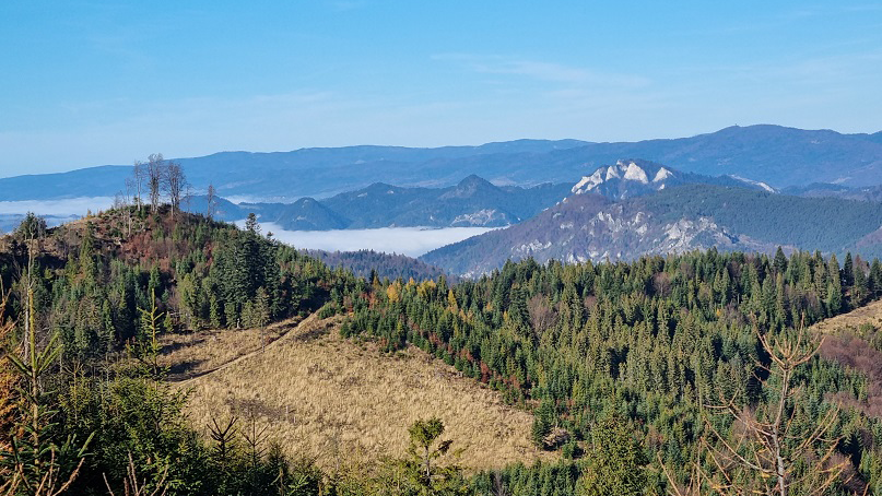
Veterný Vrch hill offers amazing views, probably the best ones in the whole Spišská Magura region. A 365° panoramic view is comparable to the views offered by famous Slovak hills, such as Choč, Kľak or Vápeč. A beautiful scenery of the eastern part of the High Tatras is supplemented with a full view of the Belianske Tatras, from Skalné vráta to the northern part with Ždiarska Vidla, Havran, Nový vrch and Muráň hills. On sunny days, you may also see part of the Polish Tatras with the Giewont Mount as well as the interesting Babia hora and Pilsko hills in the Orava Region. When looking on Kráľova Hoľa hill in the Low Tatras, you will also see the whole Levoča Mountains. Anyhow, see all that yourselves and let us know how you liked the views from the Veterný Vrch hill.
Veterný vrch (Windy Hill)
After you fully enjoy all those amazing views, and after taking some rest on pleasant spots with benches, you may start walking down the hill on the same path, and after a few meters you will get to a signpost. Turn right and follow red markers until you reach Plontana Saddle. There is one more slight ascending section ahead, but from now on, you will mostly descend. The Plontana Saddle is easily recognisable—it is a large meadow with a gazebo, benches, a fireplace, and it is intersected by an old asphalt road connecting Podolínec and Veľký Lipník villages. At this point, your journey will continue on that road towards Podolínec.
Although walking on an old asphalt road may be a bit dull, you may cheer up by enjoying the views into the forest on the left. The closest milestone is an intersection under Zbojnícky stôl (Table of Outlaws). Although Zbojnícky stôl is the name of the hill under which you will walk, one actual table of outlaws can be found directly on that intersection, as indicated by a wooden arrow. Directly above the intersection, there is a small plane with a wooden table, chairs, and an amazing view of the whole intersection. So for a while you may become an outlaw controlling the whole area. Then, your journey will continue straight up the hill along the blue trail towards Sovia poľana meadow.
The path from Zbojnícky stôl leads up the hill, but it does not take long to get to the top. After a few hundreds of meters, the terrain breaks again and the path is more-less descending.
The forest terrain will offer a few more open spots where the path traverses on the right side of the ridge. Hence, you will have a couple of chances to enjoy beautiful views of the valley around Podolínec, and your sight will rest on the peaks of the High Tatras. After you reach the intersection at Sovia poľana meadow, you may choose either to continue on the blue trail across the valley to the spa, or take the yellow trail across some more meadows. This section is partially the same as the Oxygen Route – Forest. If the terrain is wet, we recommend taking the yellow trail since the blue one is rather muddy on the way down the hill. However, the original trail continues down the blue path.
At that point, you will have to complete the last section of your journey, a forest path leading to an asphalt road in the valley of the Zálažný Stream. Even though it is often muddy, you may follow it down to a wooden bridge. The stream offers a change of getting some refreshment with clean water and cleaning your shoes from mud. Once you cross the bridge, turn right, walk down the valley, passing several cottages, until you reach a turn off the road. Follow the blue marker that will lead you to the Love and Oblivion Springs. From that point, it is just a short distance to the spa. In the spa, you will deserve having a cup of coffee, a cake or a luxury dinner in the Grand Hotel Strand****.